Cambridge G20 London Summit Newswire Archive
Page 1
of
1
Nepal :Police crackdown on the peaceful assembly of Tibetan exiles
 Our source who was present in the spot during the attack of police on peaceful Tibetan said Tibetan exiles held a memorial service at Jawalakhel Settlement on the outskirts of Kathmandu. Before that there was a notable presence of intelligence officials on that area. Police surrounded the venue for the religious service and blocked the entrance before the service started.
Italia: Silvios Bambinas
 http://www.dradio.de/aod/?station=1&broadcast=196846&datum=20110125&playtime=1295943522&fileid=038af6e9&sendung=196846&beitrag=1372478& Teil 2: Wein, Weib und Gesang -Die Partys des Silvio B. http://www.dradio.de/aod/?station=1&broadcast=196846&datum=20110126&playtime=1296029551&fileid=06fb0f37&sendung=196846&beitrag=1373379&
 Remember Hiroshima and Nagasaki!
Mayday & police brutality march in Cambridge
G20 Protest Pictures, part 4
Full Story | 1 addition | 7 comments >>
G20 Protest Pictures, part 3
G20 Protest Pictures, part 2
G20 Protest Pictures, part 1
Cambridge residents Camping for Climate Action in London's financial district
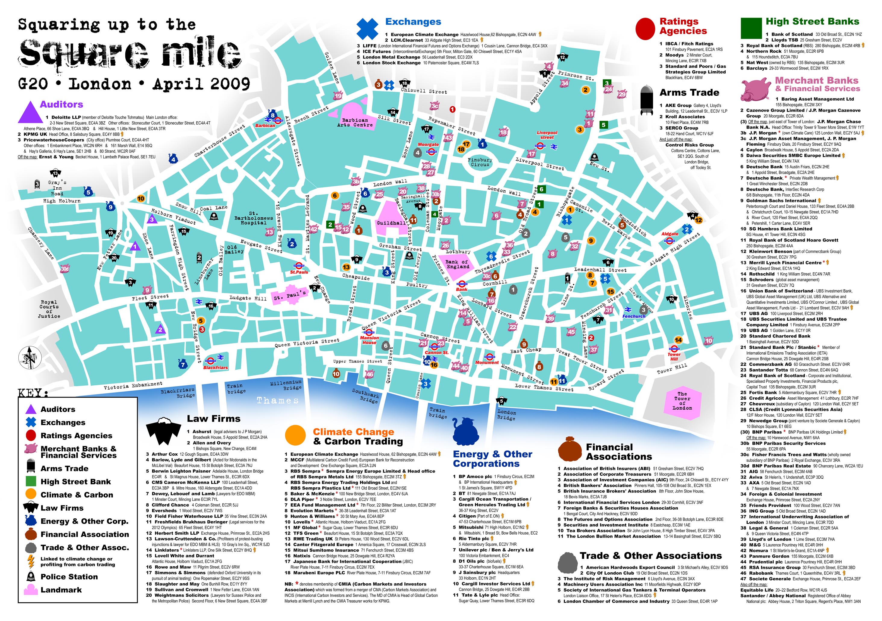
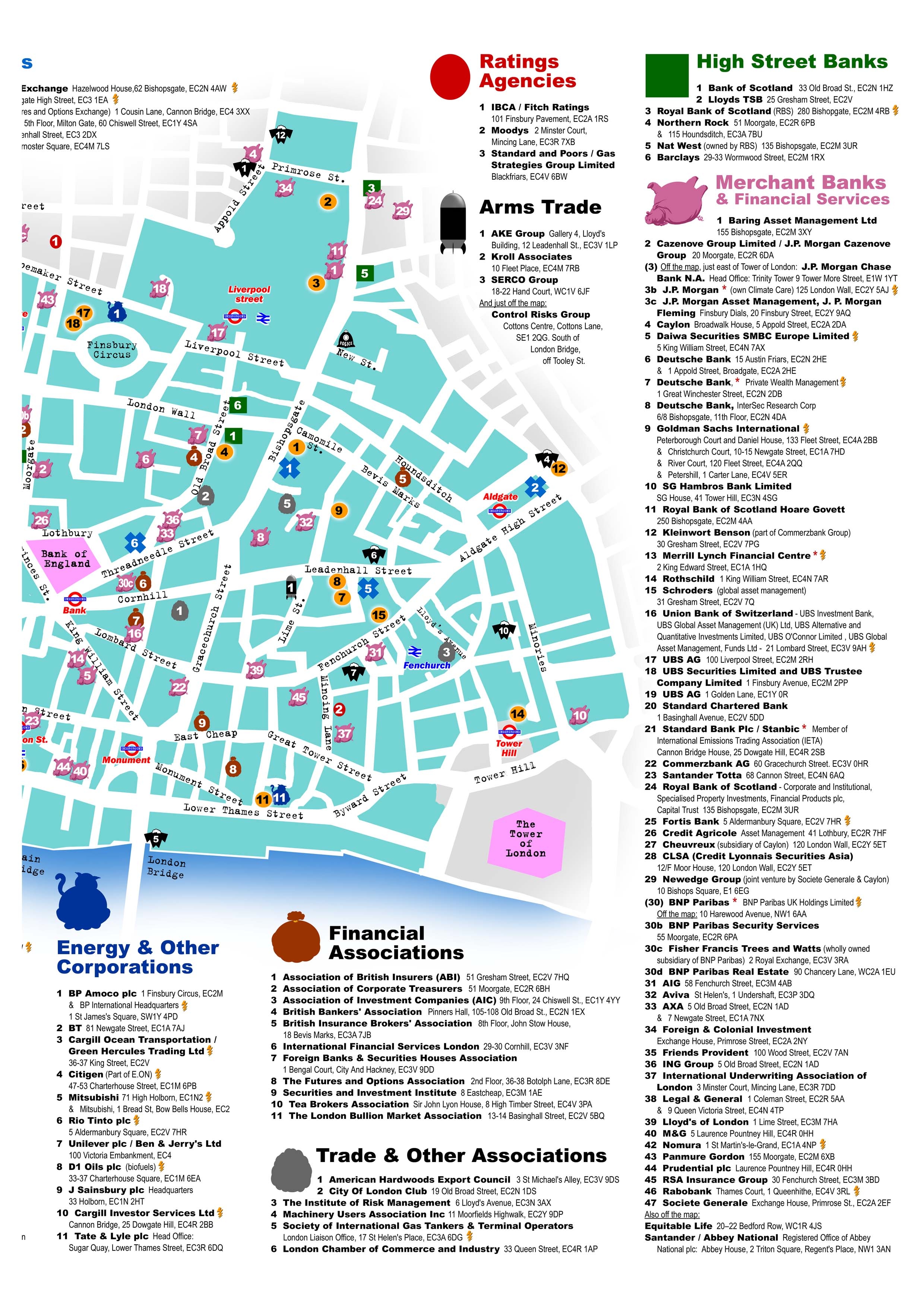
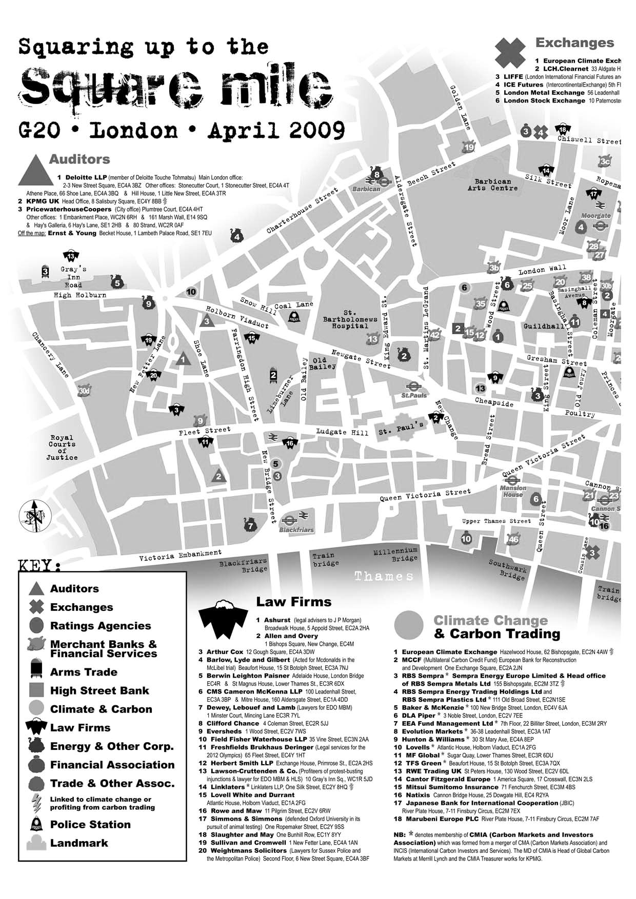
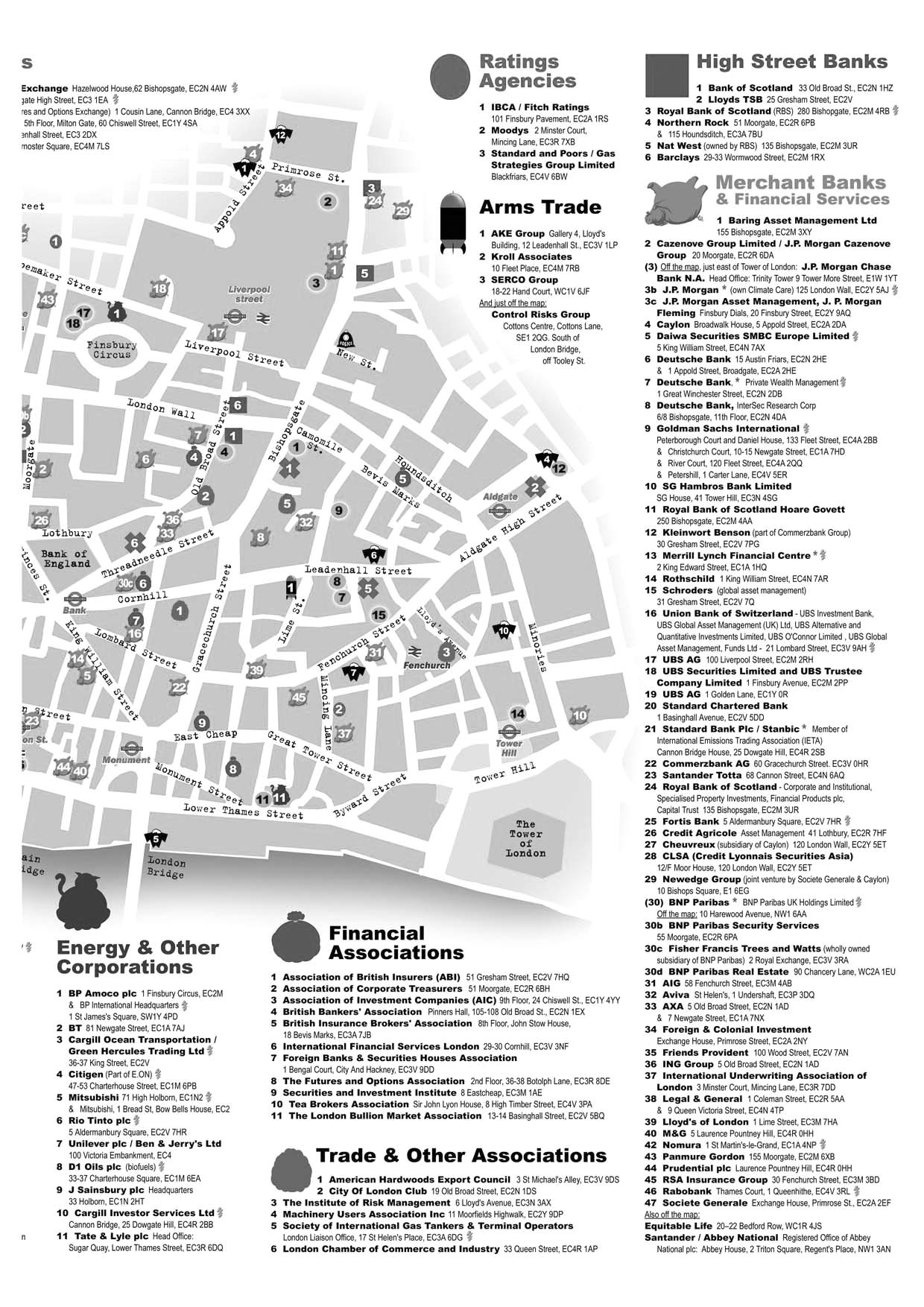
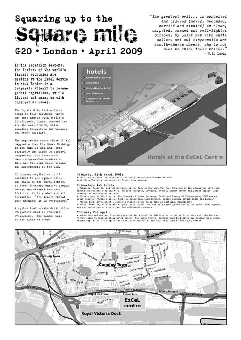
On April 1st 2009, a number of Cambridge residents successfully established a Climate Camp outside the European Climate Exchange, in protest at the UK government's contradictory policies on climate change.G20 Map - Squaring Up to the Square Mile - Easily printable versions
Get your maps here! Get your maps here! - Map of the Square Mile
Technological gremlins and exhaustion have been banished and more easily printable versions of the maps of the Square Mile and the ExCeL Centre have now been sorted. A3 is the best size for the Square Mile map, so for those without A3 printers, there are two A4 versions you can print out and stick together with old-fashioned sticky tape. The map is downloadable as a JPEG or PDF in A4, A3 and split A3 versions, in black and white or colour.
Here's the full map: Version for printing to A3 - JPG | Version for printing to A3 - PDF | Version for printing to A4 - JPG | Version for printing to A4 - PDF
However, it's best to print an A3 map on two A4 sheets and tape them together:
Here's the two parts in colour: Part One Colour PDF | Part One Colour JPG | Part Two Colour PDF | Part Two Colour JPG
And here they are in greyscale: Part One Greyscale PDF | Part One Greyscale JPG | Part Two Greyscale PDF| Part Two Greyscale JPG
And here's the map of the ExCeL centre: Excel Map PDF | Excel Map JPG
Finally, here's a Button/Banner to embed and link to the map.